Saturday, April 1, 2017

History - Pabna District

History

Image result for history of pabnaPabna District (Bengali: Paabna Jela) is a district in north-western Bangladesh. It is the southern most district of Rajshahi Division. Its administrative capital is eponymous Pabna town.

Pabna forms the south-east boundary of Rajshahi Division. Sirajganj District is on the north-east, while the Padma River, main stream of the holy river Ganges, in the south separates it from Rajbari District and Kushtia District. The Jamuna River runs along its eastern border separating it from Manikgonj District; and on the north-west it has a common boundary with the Natore District. Average maximum temperature 33.9°C, minimum 9.6°C; annual rainfall 1872 mm. Characteristically the soil of the district is divided into four, viz flood plains of the Ganges, Karatoya, Jamuna and Barind Tract. Main rivers are Ganges, Ichamati, Gumani, Baral and Hurasagar.

Archeologist Cunningham conjectured that the name Pabna might be derived from Pundra or Poondrobordhon civilization, whose capital was Mahasthangarh, the oldest city of Bangladesh, in neighbouring Bogra. But this hypothesis has not received general acceptance among scholars.

Tuesday, March 28, 2017

History of Sylhet

Image result for sylhet historySylhet came under British administration in 1765. Sylhet was strategically important for the British in their pursuit of conquering Northeast India and Upper Burma. The first commercial tea plantation in 
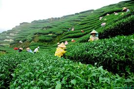
British India was opened in the Mulnicherra Estate in Sylhet in 1857. Sylhet was constituted as a municipality in 1867. Despite protests to the Governor of Bengal from its Bengali-majority population, the town was made part of the Chief Commissioner's Province of Assam in 1874 in order to facilitate Assam's educational and commercial development. The Assam Bengal Railway was established in the late 19th century to connect Assam and Sylhet with the port city of Chittagong.
In 1905, Sylhet became a divisional headquarter of Eastern Bengal and Assam. In 1912, it was again separated from Bengal and made part of Assam Province. The Muslims of Sylhet generally favored reunion with Bengal. The Bengali Muslim elite in Dacca also vouched for Sylhet's reunion with Bengal. By the 1920s, organizations such as the Sylhet Peoples Association and Sylhet-Bengal Reunion League mobilized public opinion demanding the division's incorporation into Bengal. Nevertheless, the Bengalis of Sylhet were influentially placed in the administration, educational institutions and commercial activities of Assam.
Due to the size of Sylhet's Bengali Muslim majority, the All India Muslim League formed the first elected government in British Assam.
The numbers of lascars grew between the two world wars, with some ending up in the docks of London and Liverpool. Sylhet's lascars married English women. During World War II, many fought on the Allied front before settling down in the United Kingdom, where they opened Indian curry cafes and restaurants.
In 1947, following a referendum, almost all of erstwhile district of Sylhet became a part of East Bengal in the Dominion of Pakistan, barring its Karimganj sub-division which was incorporated into the Dominion of India. The referendum was held on 6 July 1947. 239,619 people voted to join Pakistan and 184,041 voted to be part of India. The referendum was acknowledged by Article 3 of the Indian Independence Act 1947.

Bogra History


Image result for bogra historyHistory
Ancient history:
The history says it was the oldest city of Bengal in the Great Emperor Ashoka's India. He conquered the Bengal (Bongo) and founded this old city called Pundra Bardhan. It was famously written in famous ancient travellers of that time.
British rule:
Bagura or Bogra was a town and district of British India, in the Rajshahi division of eastern Bengal and Assam. The town is situated on the right bank of the river Karatoya. But the present District Of Bogra, was first formed in 1821. It contains an area of 1359 mi² (3,520 km²). In 1901 the population of the town was 3,094 and of the district (on a reduced area) was 854,533, showing an increase of 11% in the decade. The district stretches out in a level plain, intersected by numerous streams and dotted with patches of jungle. The Karatoya River flows from north to south, dividing it into two portions, possessing very distinct characteristics. The eastern tract consists of rich alluvial soil, well watered, and subject to fertilizing inundations, yielding heavy crops of coarse rice, oil-seeds and jute. The western portion of the district is high-lying and produces the finer qualities of rice. The principal rivers are formed by the different channels of the Brahmaputra, which river here bears the local names of the Konai, the Daokoba and the Jamuna, the last forming a portion of the eastern boundary of the district. Its bed is studded with alluvial islands. The Brahmaputra and its channels, together with three minor streams, the Bangali or Bangalee, Karatoya and Atrai, afford admirable facilities for commerce, and render every part of the district accessible to native cargo boats of large burden. The rivers swarm with fish. The former production of indigo is extinct, and the industry of silk-spinning is decaying. There is no town with as many as 10,000 inhabitants, trade being conducted at riverside marts. Nor are there any metalled roads. Several lines of railway (the Eastern Bengal, &c.), however, serve the district.
Battle of Bogra:
In the Bangladesh Liberation War, the area witnessed a fierce battle - Battle of Bogra - between the allied troops of Mitro Bahini and Indian Army which defeated the Pakistan Army.

Monday, March 27, 2017

History of Dhaka City

History of Dhaka City:
Image result for dhakaDhaka City formerly spelled Dacca, named Jahangirnagar during Mughal era is the capital of Bangladesh and the principal city of Dhaka Division. Dhaka is a megacity and one of the major cities of South Asia. Located on the banks of the Buriganga River, Dhaka, along with its metropolitan area, had a population of over 16 million in 2011, making it the largest city in Bangladesh. It is the 9th largest city in the world and also 28th among the most densely populated cities in the world. Dhaka is known as the City of Mosques and with 400,000 cycle rickshaws running on its streets every day, the city is also described as the Rickshaw Capital of the World.
Under Mughal rule in the 17th century, the city was known as Jahangir Nagar. It was a provincial capital and a centre of the worldwide muslin trade. The modern city, however, was developed chiefly under British rule in the 19th century, and became the second-largest city in Bengal after Calcutta (presently Kolkata). After the Partition of Bengal in 1905, Dhaka became the capital of the new province of Eastern Bengal and Assam but lost its status as a provincial capital again after the partition was annulled in 1911. After the partition of India in 1947, Dhaka became the administrative capital of East Pakistan, and later, in 1971, the capital of an independent Bangladesh. During the intervening period, the city witnessed widespread turmoil; this included many impositions of martial law, the declaration of Bangladesh’s independence, military suppression, devastation during war, and natural calamities. Modern Dhaka is the centre of political, cultural and economic life in Bangladesh. Although its urban infrastructure is the most developed in the country, Dhaka suffers from urban problems such as pollution and overpopulation. In recent decades, Dhaka has seen modernisation of transport, communications and public works. The city is attracting large foreign investments and greater volumes of commerce and trade. It is also experiencing an increasing influx of people from across the nation, this has reportedly made Dhaka the fastest growing city in the world. Lalbabh Fort constructed in the mid 17th century by Prince Mohammed Azam Shah, son of the Emperor Aurangzeb, and the Fort contains the tomb of Bibi Pari, daughter of Shaista Khan. The existence of a settlement in the area that is now Dhaka dates from the 7th century. The city area was ruled by the Buddhist kingdom of Kamarupa and the Pala Empire before passing to the control of the Hindu Sena dynasty in the 9th century. The name of the city may have derived after the establishment of the Goddess Dhakeshwari’s temple by Ballal Sena in the 12th century. The town itself consisted of a few market centres like Lakshmi Bazar, Shankhari Bazar, Tanti Bazar, Patuatuli, Kumartuli, Bania Nagar and Goal Nagar.